Nova Scotia

Home » Nova Scotia » Page 2

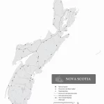
Nova Scotia without names map – Explore Canada with ease using our printable maps!

Nova Scotia without names map

The outline map of Ontario depicts the province’s boundary, coastline, and major water systems, offering a simplified and clear view of the region’s significant features. By excluding the names of major political and geographical features, the map emphasizes the importance of Ontario’s essential water bodies, which have played a crucial role in the province’s history and development. The map can be helpful for various purposes, including educational, environmental, and recreational pursuits.
Home » Nova Scotia » Page 2

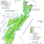
Nova Scotia Relief Map – Explore Canada with ease using our printable maps!

Nova Scotia Relief Map

The relief map of Nova Scotia provides detailed topographical information on the region, including elevation data and major lakes. The map uses hypsometric tints and spot elevations to represent different elevations, making it a valuable tool for various applications, such as natural resource management, scientific research, emergency management, and tourism.

Home » Nova Scotia » Page 2

Kejimkujik National Park

Kejimkujik National Park and National Historic Site is a hidden gem located 160 km southwest of Halifax in southwestern Nova Scotia. Established in 1974, this 403.7 km2 park offers a natural haven for those seeking tranquility and adventure. The park’s name, derived from a Mi’kmaq word, refers to the exertion required in paddling across Kejimkujik … Read more

Home » Nova Scotia » Page 2

Cape Breton Highlands National Park

Cape Breton Highlands National Park, established in 1936, is a breathtaking wilderness paradise located on the northern tip of Cape Breton Island, Nova Scotia, Canada. This majestic park covers an area of 948 km2 / 366.02 mi2 and offers a diverse landscape of rugged cliffs, sheltered coves, rocky beaches, bogs, and dense forests, all under … Read more