Welcome to the download page of Canada Maps, where Northwest Territories Relief Map is free to download in both printable JPG and PDF file formats. Whether you’re planning a road trip, researching a project, or want to understand better the political or geographical Canada, our collection of maps has got you covered.
About the Northwest Territories Relief Map
Northwest Territories is a vast and diverse region of Canada, characterized by various terrains, including mountains, plateaus, and vast forests. A relief map of this region is essential to help users understand the area’s elevations and topography and make informed decisions about their travels.
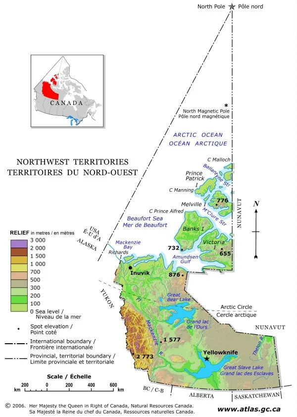
Our website offers a relief map of the Northwest Territories that displays the region’s elevations using hypsometric tints. These tints are a gradation of different colors that indicate variations in elevation across the region. The relief map also includes spot elevations and major lakes. Elevation ranges are included in the map legend, which helps users understand the colors and the corresponding elevations.
Our website’s relief map of Northwest Territories was derived from the Canada-Relief, Fifth Edition, National Atlas of Canada, published in 1986. This map is a trusted source of geographic information used by researchers, educators, and outdoor enthusiasts for decades.
The relief map of the Northwest Territories is a valuable tool that can be used in various ways. It can help hikers and outdoor enthusiasts plan their routes and understand the terrain’s elevations, identifying potential challenges and areas of interest. It can also aid in planning and developing communities, allowing planners to understand the region’s topography and consider its impact on infrastructure and land use.
Geologists and geology students can use the relief map to study the region’s topography and identify geological formations. Environmental researchers and students studying the environment can use the map to study the impact of climate change, water availability, and other environmental factors.
Overall, our website’s relief map of the Northwest Territories is an essential tool that provides information for those studying, working, or exploring the region. Its detailed and accurate data, combined with the easy-to-use format, make it an invaluable resource for anyone seeking to understand the area’s topography and natural features.

The image is a relief map of the Northwest Territories, a vast and sparsely populated region in northern Canada. This map is designed to illustrate the topographical features of the Northwest Territories, emphasizing its physical landscape. The map’s dimensions are 600 pixels in width and 842 pixels in height, and it is presented in the WebP format.
As a relief map, it highlights the elevations and depressions in the terrain of the Northwest Territories. This includes the territory’s rugged Arctic landscapes, mountain ranges, and extensive river systems. Relief maps are particularly useful for understanding the three-dimensional aspect of a landscape, which is essential for geographical studies, environmental research, and planning in such a unique and challenging environment.
The image’s resolution should be sufficient to convey the general topography of the Northwest Territories. This makes it a valuable tool for anyone interested in the physical geography of this northern Canadian territory, for educational purposes, or planning purposes related to the terrain.
Download link for Relief map Northwest Territories – Bilingual printable JPG.
Download link for Relief map Northwest Territories – Bilingual printable PDF.
Looking for more similar maps to Northwest Territories Relief for printing? Check them out here.
Downloading these maps is easy and hassle-free. Select the map you want, choose the file format that works best for you, and hit the download button. These Canada-related maps are designed to be printer-friendly, so you can print them out at home or take them to a local print shop.
Use cases for the Northwest Territories Relief Map
The Northwest Territories relief map, available on our website, is a valuable tool for various use cases, including:
- Outdoor recreation: The relief map can help hikers, mountaineers, and outdoor enthusiasts plan their routes and understand the terrain’s elevations, identifying potential challenges and areas of interest.
- Geological studies: Geologists and geology students can use the relief map to study the region’s topography and identify geological formations.
- Urban planning and development: The relief map can aid in the planning and developing of cities, towns, and communities, allowing planners to understand the region’s topography and consider its impact on infrastructure and land use.
- Environmental studies: The relief map can help researchers and students studying the environment to understand the terrain’s elevation, which can be crucial in studying the impact of climate change, water availability, and other environmental factors.
- Education: The relief map can be a valuable resource for teachers and students studying geography, geology, and other subjects. It can help students better understand the area’s topography and natural features.
- Resource management: The relief map can assist resource managers in understanding the terrain’s elevations and features to make informed decisions about resource extraction, including mining and forestry.
- Emergency management: The relief map can aid emergency management professionals in understanding the terrain and how it may impact emergency response and rescue operations.
Overall, the Northwest Territories relief map is a versatile tool that provides a wealth of information and can benefit a range of purposes.
We are committed to providing high-quality, informative maps accessible to everyone. These Canada maps are available for personal or educational purposes, and we encourage you to share them with your friends and colleagues.
Driving Directions, Google Maps, and more
To use these services, please visit the Driving Directions, Google Maps, or OpenStreetMap pages.
Provinces and territories
If you are looking for detailed information on the Canadian provinces and territories, consult the following pages: Alberta, British Columbia, Manitoba, New Brunswick, Newfoundland and Labrador, Northwest Territories, Nova Scotia, Nunavut, Ontario, Prince Edward Island, Quebec, Saskatchewan, and the Yukon.
The map of Northwest Territories Relief above contains information licensed under the Open Government Licence – Canada.
Thank you for visiting Canada Maps! We hope our maps will help you explore and discover the beauty of Canada.