Saskatchewan, a province located in Western Canada, is known for its vast prairies, wheat fields, and the rugged Canadian Shield. With its unique geography and diverse landscapes, it’s no wonder that Saskatchewan is a popular destination for tourists and locals alike. A detailed road map is a must-have if you’re planning a road trip or just want to explore the province. In this blog post, we’ll introduce you to the Saskatchewan road map available on canadamaps.com and show why it’s the perfect tool for your next adventure.
Saskatchewan Road Map
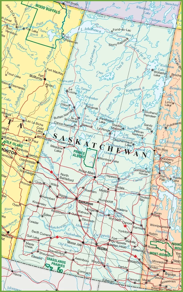
This map shows Saskatchewan’s cities, towns, rivers, lakes, Trans-Canada highways, major highways, secondary roads, winter roads, railways, and national parks.

The Saskatchewan road map is a comprehensive visual representation of the province’s roadways, displayed at a resolution of 1164×1857 pixels. It details the major highways, including the Trans-Canada Highway, and secondary roads that crisscross the province, facilitating travel between cities, towns, and rural areas. The map includes important geographical features such as lakes and rivers and may also provide information on distances and locations of interest for travelers and residents alike.
Please visit this page for other map resources or Google Maps.
What are Saskatchewan road maps used for?
Road maps are essential for anyone traveling by car, whether commuting to work, driving across the country, or exploring a new province. A road map is a detailed guide that shows the location of roads, highways, and cities, making it easy to navigate from point A to point B. Saskatchewan road maps are handy because they show the major highways, secondary roads, winter roads, and railways. This makes planning your route easier and choosing the best roads based on your preferences and weather conditions.
Did you know about Saskatchewan?
- Saskatchewan is known as the “land of living skies” because of its vast horizons and spectacular sunsets.
- The province has five national parks: Prince Albert National Park, Grasslands National Park, Wood Buffalo National Park, Riding Mountain National Park, and Wapusk National Park.
- Saskatchewan has more than 100,000 lakes and rivers, making it a popular destination for fishing and water sports.
- The Trans-Canada Highway, which stretches from Victoria, British Columbia, to St. John’s, Newfoundland, passes through Saskatchewan and is the main artery of the province’s transportation system.
Explore Saskatchewan with the Saskatchewan Road Map
The Saskatchewan road map available on canadamaps.com is the ultimate tool for exploring the province. This map shows the major highways, secondary roads, winter roads, railways, and national parks. Here are some of the features of this map:
Cities and Towns: The Saskatchewan road map shows the location of all major cities and towns, including Saskatoon, Regina, Prince Albert, and Moose Jaw. This makes it easy to plan your route and find accommodations and restaurants.
Rivers and Lakes: Saskatchewan is known for its abundance of lakes and rivers, and this road map shows the location of all significant bodies of water. Whether planning a fishing trip or just enjoying the scenery, this map will guide you to the best spots.
Trans-Canada Highway and Major Highways: The Trans-Canada Highway is the main artery of Saskatchewan’s transportation system. This map shows its location and all major highways in the province. This makes it easy to plan your route and navigate through the province.
Secondary Roads and Winter Roads: Besides the major highways, the Saskatchewan road map also shows all secondary and winter roads. This is especially important if you’re traveling during the winter months when some roads may be closed or difficult to navigate.
Railways: Saskatchewan has an extensive railway system, and this road map shows the location of all major railway lines. This is useful if you’re planning a trip by train or want to avoid crossing railway tracks while driving.
Conclusion
Whether planning a road trip, exploring the province, or just needing a detailed guide to navigate through Saskatchewan, the Saskatchewan road map available on canadamaps.com is the perfect tool for your next adventure. With its detailed information on cities, towns, rivers, lakes, highways, secondary roads, winter roads, railways, and national parks, this map will guide you to the best spots in the province.