Explore Eastern Canada’s Natural and Urban Landscapes with Canada Maps
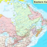
This map shows provinces, cities, towns, highways, roads, railways, ferry routes, and national parks in Eastern Canada.
This map shows provinces, cities, towns, highways, roads, railways, ferry routes, and national parks in Eastern Canada.
Adventure Alberta attractions British Columbia Canada cities culture Exploration Geography highways Hiking Historic Sites History indigenous communities Lakes map maps Municipality national parks natural wonders Nature Northwest Territories Nova Scotia Ontario Outdoor activities Outdoor Adventures printable provinces Provincial Parks Quebec railways rivers road map roads Road trip Saskatchewan scenic driving routes Secondary Roads tourism Tourist Map towns Trans-Canada Highway travel Travel Tips Wildlife
Arr. Saint-Georges, Rue Jules Lefebvre Rue des Italiens, 75009 Paris
Mon to Friday
9:00 am to 6:00 pm, UTC
Canada map and other route planner sites with exceptional information for countries around the globe.
The information provided on the Canada Map website may contain affiliate links. Please read our Terms and Conditions, as well as our Privacy Policy, for more information. Note that pricing, operating hours, or other information provided may have changed since the initial publication.
The CanadaMaps.com website uses Google Maps, Here Maps, Bing Maps, MapQuest, and OpenStreetMap to select the map provider that best meets their and their user’s needs regarding maps. Users should be able to select the map provider that best meets their needs based on price, quality, or other factors. Our decision to use multiple map providers is also driven by our commitment to providing users with the most accurate and up-to-date maps and city information possible. We can offer more comprehensive coverage of the world by using multiple providers. Please note that we are not affiliated with or sponsored by any map-providing company you find on this website.
© 1999-2024 Domino Services Ltd. & Canada Maps.com
